


Introduction:
Delhi’s air quality plunged to “severe” levels this week, triggering health alerts across the National Capital Region. Amid rising public concern, India’s Central Pollution Control Board (CPCB) unveiled a high-resolution real-time air quality map, enabling citizens to track hyper-local pollution hotspots and take immediate precautions. (62 words)
New CPCB Air Quality Map: Key Features
Launched June 18, 2025, the interactive dashboard (cpcb.nic.in/aqi-map) offers:
🔹 Live AQI Updates: Data from 1,200+ monitoring stations across India.
🔹 Pollutant Breakdown: Hourly PM2.5, PM10, NO2, SO2, and ozone levels.
🔹 Hotspot Identification: Red zones flagged within 1km accuracy (e.g., Anand Vihar AQI 482 at 8 AM).
🔹 Source Analysis: Annotates major contributors (traffic, construction, industry).
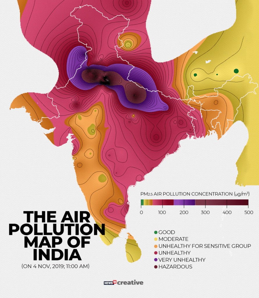
Delhi-NCR’s “Severe” Emergency

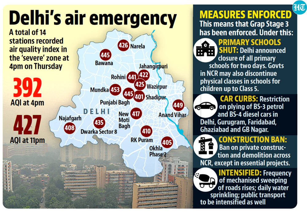
Current crisis highlights (Source: CPCB/Safar):
- Worst-Affected: Dwarka (AQI 478), Noida (463), Gurugram (455).
- Primary Culprits: Dust storms (43%), vehicle emissions (28%), biomass burning (12%).
- Health Advisory: Schools shift online; vulnerable groups urged indoors.
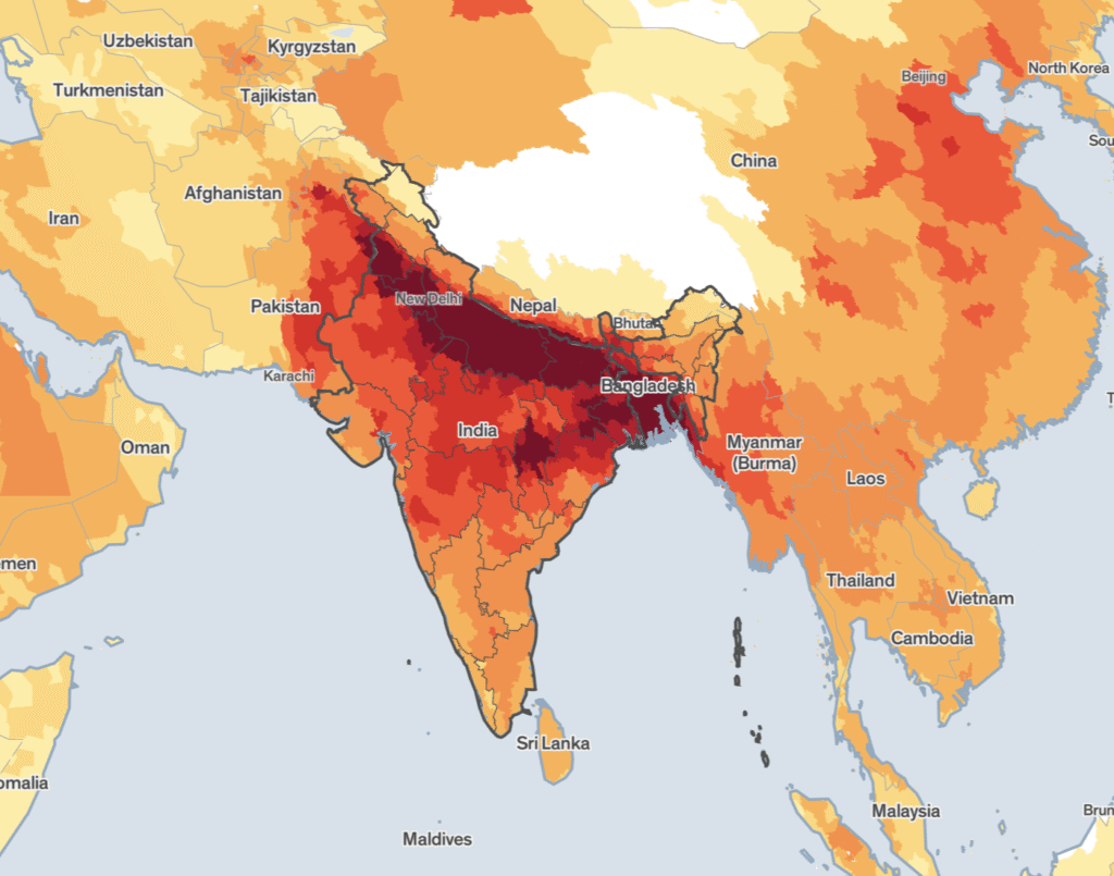
Why This Map Matters for Indians
- Personalized Safety: Plan outdoor activities using neighborhood-level data.
- Accountability: Pinpoints industrial violators near residential zones.
- Travel Planning: Check air quality for destination cities like Mumbai or Kolkata.
- National Coverage: Tracks 150+ cities including Chennai, Bengaluru, and Lucknow.
Health Risks in Polluted Zones

Doctors report 30% surge in respiratory ER cases (AIIMS data). Critical risks:
“PM2.5 penetrates lungs, causing asthma attacks and long-term heart damage,” warns Dr. Arvind Kumar, Lung Care Foundation.
Vulnerable groups: Children, elderly, pregnant women, and outdoor workers.
Government Actions & Public Response
- Graded Response Plan (GRAP) Activated: Diesel genset ban, construction halted in hotspots.
- Citizen Use Surge: Map traffic up 300% since launch (CPCB server logs).
- Criticism: Activists demand more stations in rural areas and industrial clusters.
Future Developments
CPCB plans to integrate:
- 3-Day Forecasts: AI-based pollution predictions.
- Health Recommendations: Customized alerts by risk group.
- Fire Tracking: Real-time farm-burn monitoring via satellite sync.
Summary:
CPCB’s real-time air quality map provides a critical tool for Indians battling hazardous pollution, especially in Delhi-NCR’s current “severe” crisis. By delivering hyper-local data and source identification, it empowers citizens to protect their health while pressuring authorities for targeted action. As winter looms, this platform may prove vital in India’s fight for breathable air.